Succeeding in the New World – Colonial America

Skip Main Navigation
  • Home
  • Lesson Activities
    • Welcome to Colonial America
    • The Engineering Design Process
    • Explore the Colonies
    • Describe a Settlement
    • Envisioning a New World
    • Research Features of Your Region
    • Criteria for a Successful Settlement
    • Overview of Coordinate Grids
    • Build Your Settlement
    • If I knew then what I know now…
  • Student Resources
    • Table of Contents
    • Glossary
    • Engineering Portfolio
    • Did You Know
    • Rubric for Informational Column
  • Teacher Resources
    • Lesson Preparation
    • Lesson Overview
    • Objectives
    • Using This Site
    • Technology
    • Schedule
    • Essential Questions
    • Enduring Understandings
    • Background Information
    • Teacher Notes
    • Assessment
    • Appendices
  • STEM Careers
  • Welcome to Colonial America
  • The Engineering Design Process
  • Explore the Colonies
  • Describe a Settlement
  • Envisioning a New World
  • Research Features of Your Region
  • Criteria for a Successful Settlement
  • Overview of Coordinate Grids
  • Build Your Settlement
  • If I knew then what I know now…

Envisioning a New World

Now that you have conducted research, it is time to focus on your own colony. Here is your scenario:

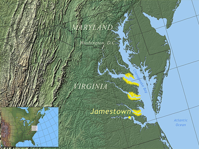
You are part of a group of colonists who plan to establish a settlement in the New World. After hearing about other settlements, you have decided to try to settle along the middle of the Atlantic coast. Previous explorers have told you that there is a large bay that extends past the settlement at Jamestown. You plan to sail further into the bay and find an area to settle near the mouth of a river. The yellow areas on the map below show possible settlement locations.

This is a geographical map showing the east coast of the United States along the middle of the Atlantic Ocean. From north, the locations of Maryland, Washington, D.C., Virginia and Jamestown are labeled on the map. The Chesapeake Bay extends from Maryland through Virginia. The mouths, or openings, of three tributaries along the western portion of Chesapeake Bay are highlighted.

Teacher Note

Students should read the information on the page. Point out to students the location of the new settlement, especially in relation to the four case study settlements.

Read More

Essential Questions

  • How do we know what we know about the past?
  • What are the challenges and responsibilities of historians?
  • How do geographic characteristics determine choices? (For, example, climate guides decisions about food, clothing and shelter.)
<< Go to First page < Go to Previous page
  • Go to page 1
  • Go to page 2
  • Go to page 3
  • Go to page 4
  • Go to page 5
  • Go to page 6
  • Go to page 7
  • Go to page 8
  • Go to page 9
  • Go to page 10
Go to Next page > Go to Last page >>
Site Map | Accessibility | About

This website is a production of Maryland Public Television/Thinkport in collaboration with the Maryland State Department of Education. The contents of this website were developed under a grant from the U.S. Department of Education. However, those contents do not necessarily represent the policy of the U.S. Department of Education, and you should not assume endorsement by the Federal Government.

Thinkport Maryland State Department of Education Maryland - STEM education

2014 Copyright Maryland State Department of Education

Closed-captioned logo

Contact the MSDE Office of Instructional Technology for copyright questions.